Please use a Javascript-enabled browser.
news.gov.hk
*
SitemapHome
*
*
*
Weather
*
*
*
Traffic Conditions
*
*
*
Categories:
*
**
Business & Finance
*
*
**
At School, At Work
*
*
**
Health & Community
*
*
**
Environment
*
*
**
Law & Order
*
*
**
Infrastructure & Logistics
*
*
**
Admin & Civic Affairs
*
*
*
*
On the Record
*
*
*
News in Focus
*
*
*
City Life
*
*
*
HK for Kids
*
*
*
Photo Gallery
*
*
*
Reel HK
*
*
*
Speaking Out
*
*
*
Policy Address
*
*
*
Budget
*
*
*
Today's Press Releases
*
*
Press Release Archive
*
*
*
About Us
*
*
*
*
*Judiciary
*Legco
*District Councils
*Webcasts
*Message Videos
*Government Information Centre
*Electronic Services Delivery


*
Traditional ChineseSimplified ChineseText onlyPDA
*
July 22, 2005
Meteorology
*
Real-time satellite images available online
*
FY-2C satellite
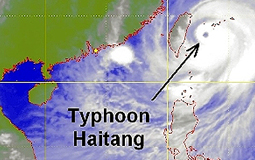
Eye on the storm: The Chinese FY-2C satellite captured Typhoon Haitang off Taiwan on July 18.
*

Real-time imagery from the Chinese Fengyun-2C satellite is now avilable on the Hong Kong Observatory's website, giving the public a clearer weather picture.


FY-2C satellite is a geostationary meteorological satellite operated by the China Meteorological Administration. Launched last November, it went into operation last month.


It is 36,000 kilometres above the equator enabling it to capture cloud images covering a wide area, including Asia, the western Pacific, Australia, the Indian Ocean and eastern Africa, useful for tracking typhoons and other storms.


The website features an animated sequence depicting the movement and development of clouds.


Go To Top
* Safer Living *
*
*
Print This Print This Page
Email This E-mail This
*
*
*
Related Links
*
*
*
Other News
More..
*
*
  Brand Hong Kong
*
*